Village of Bath
Understanding the significance of Bath in Ontario is crucial to understanding Ham House.
Ontario was originally part of New France until the British conquest of western New France at the Battle of Fort Frontenac and the Battle of Fort Niagara in 1759. Prior to the American Revolutionary War, excepting a few fur traders and the military garrison at Niagara, there was virtually no European settlement in Ontario.

Figure 1. Fort Frontenac and Cataraqui, 1758
With the end of the American Revolutionary War in 1783, large refugee camps were established at Sorel, Quebec for those displaced out of the American Colonies - particularly from New York City and Virginia. In addition, elements of the British Army and loyalist paramilitary forces with their allies in the Iroquois Confederacy were at Carlton Island near the top of the St. Lawrence River.
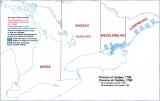
In 1783 the British Government made the decision to open western Quebec to settlement and in the winter of 1783/1784 the first town site was surveyed at Cataraqui (Kingston) around the ruins of Fort Frontenac(1). Later titled 'United Empire Loyalists' (UEL), elements of the army and refugees from Sorel began settling newly surveyed lots between Kingston and Adolphustown late in the summer of 1784. Capt. Hawley's House still survives in Bath from the year of that initial settlement. On July 24, 1788 Lord Dorchester proclaimed the civil 'District of Mecklenburg' from the River Gananoque to the River Trent, naming the five townships of Cataraqui: Kingstown, Ernestown, Fredericksburg, Adolphustown and Marysburg. By 1789 Kingstown became known as Kingston.

Figure 2. First Districts 1788
For the first several years there was extensive starvation (2), the population being entirely dependent on the British Army for food. With creation of the districts came the courts which transferred power from the army. By 1791 almost the only completed surveys in what is now Ontario were in the District of Mecklenburg. The Constitutional Act of 1791 divided Quebec into Upper and Lower Canada (relative to their positions on the St. Lawrence River), separating the Loyalist population which was largely English and protestant from the French population that was catholic. In 1792 Mecklenburg District was renamed Midland District and in 1798 the district was reorganized, creating the counties of Addington, Frontenac, Hastings, Lennox and Prince Edward. In 1831 Prince Edward and in 1837 Hastings were separated into their own districts. In 1841 Upper and Lower Canada were combined into the 'United Province of Canada' with Upper and Lower Canada renamed Canada West and East, respectively. The capital of the United Canadas was first Kingston, then Montreal, followed by Toronto and Quebec City. In 1849 Midland District was replaced by Frontenac and Lennox and Addington Counties. Finally, modern Ontario was formed out of Canada West with the creation of the Dominion of Canada in 1867.
Though Kingston was the seat of Midland district, towns were laid out at Ernestown and Adolphustown which were more central and surrounded by better farmland than Kingston. By the early 1800's Ernestown, with its well-protected deep water port, was Kingston's rival for commerce(3). Ham House was originally a store and is located at the main intersection of that village.
The original Ernestown was surveyed out of the 152 acre farm lot #10 of John Davy, a member of Jessup's Rangers during the American Revolutionary War. In 1819 the village was renamed Bath after the city in England.
Figure 3. The region of Bath
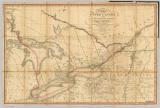
To give context to Bath's status in the colony at the time of Ham House construction in 1816, it had shipyards, many taverns and an academy. The isolation of Upper Canada from the 'Empire' is made clear by the fact that before the Erie and Lachine canals were constructed in the mid 1820's, the only way to bring goods into the Great Lakes was by 'batteaux' - basically large canoes. Though A. Danforth was commissioned by the government of Upper Canada in 1799 to construct a road from York to Kingston, only the original Bath Road between Kingston and Bath and onward to Adolphustown was marginally passable in summer. With improvements to the Kingston Road in 1817, the first stage coach to York from Kingston was established. Prior to this wagons could travel only as far west as Carrying Place. Beyond Carrying Place land travel was by horseback with an Indian guide(4). Transportation in Upper Canada was mainly by water and Bath was a major shipbuilding centre. The SS. Frontenac was the first steamship on the Great Lakes and was launched at Bath (then Ernestown) in 1817.

Figure 4. Development of Upper Canada by 1818
The importance of Bath began to wane in the early 1830's with the construction of the 'Great Road' or the Governor's Road between Kingston and Napanee (now Highway 2). With the establishment of the counties, the seat of power (and courts) shifted to Napanee and when the Grand Trunk Railway came in the late 1850's, Bath was by-passed, sealing its fate for the century and a half to come. It is the declining prosperity of a once very important community that has preserved the largest concentration of very early Upper Canada buildings in the province.
References
1. Richard A. Preston, "Kingston Before the War of 1812. A Collection of Documents", University of Toronto Press, 1959.
2. Bruce Wilson, "As She Began, An Illustrated Introduction to Loyalist Ontario", Dundurn, 1981
3. Walter S. Herrington, "History of the County of Lennox and Addington, The Macmillan Company of Canada, 1913
4. Edwin C. Guillet, "Pioneer Inns and Taverns, Volume III.". Ontario Publishing Company, 1958.
